Tunal Petroglyphs
A Catholic cemetery keeps a… pantheistic shrine?
By Nelson Peñaherrera. Photos by Alesban López.


SAPILLICA, Peru – “Cachirís Mount is straight there and Pilán Mount is mostly on the right,” Sapillica [pronounce “Sapijicah”] District Municipality’s Alesban López points me out, whom I am riding a motorcycle again , on our way to Tunal, 37 km away the southwest of the district capital. A local told him there are rocks “pretty identical” to those he featured on his Facebook account.
We have to go down from Sapillica town until Timbes [pronounce “Timbehs”], then climbing up until 1617 meters altitude according to the GPS (global positioning system) device the crew carries within. An hour 20 minutes, at least on motorcycle, by the west flank of Andean Western Range, viewing the coast along the full trail.
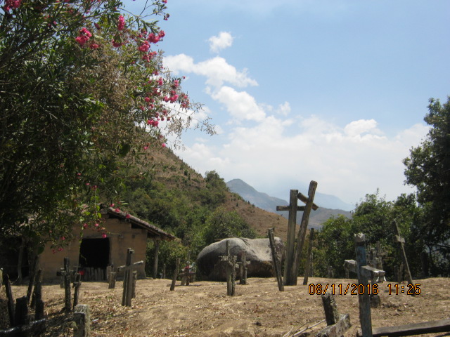
In Tunal, we are on the spine of the mountain, the rocks are so little (1,5 meters by si, approximately) those just could carve one petroglyph per each one of them, and meteorization has gotten that even one of the rocks had broken interrupting a 6-round spiral spinning in counterclockwise sense. We named that rock in particular as Tunal 2. It is located in one of the Catholic town cemetery’s sides where the oldest cross is 1941, until the crew could verify.
There is another one in the center of the cemetery we
named Tunal 3, which carving is better kept and it has resulted intriguing
because it seems a meander repeating simetrically aside. From far, it
looks like a human shape abstraction, but it’s just an impression. Did the
ancient artist really wanted to represent that?


A lookout
Tunal 1, located about 200 meters away the cemetery, is on a mountain corner, where we can see Cachirís Mount (3360 meters altitude?) in front, Frías District, the highest point of Andean Western Range in Piura Department, and enigmatic Pilán Mount, also Frías Distritct, where a strong UFO activity had happened mid-October 2016, according to locals’ reports. Tunal 1 looks at the sky, like most of petroglyphs in Samanga, where it is supposed the graphic style was created.
Those three petroglyphs seem not to fit to nearby water current pattern (Sáncor River is still so far of here), but it is affirmed Tunal 1 is used as a lookout even today. Actually, the whole flat where Chulucanas and Tambogrande cities are settled is visible from here. This is the limit of Upper and Middle Piura Valleys and this is an observation that Alesban López stresses. “This is already another basin – Piura’s,” he says remembering Loma Alta and Trujillo Petroglyphs are in Upper Chipillico River, just in Chira Basin. Is this fact relevant?


Grapes Cluster?
Currently in Sapillica, the East-west path the
petroglyphs should follow seems not to accomplish, but in all case something
could look like a grapes cluster that, according to Archeologist Daniel Dávila, could fit much to seq’es or virtual lines linking several
sacred sites. People who joined this exploration crew assures there are more
places in the rest of 70 villages in Sapillica District. The research has just
begun.
© 2016
Asociación Civil Factor Tierra. All Rights Reserved. We thank Edgar del Solar for contributing on this assignment. Look at more photos and
talk to the explorers on Facebook. Comment this in the box below or on our Twitter account. Would you like to
know the places quoted in this story? Write us at factortierra@gmail.com for more
information.


Comentarios
Publicar un comentario