Entradas

Mostrando las entradas con la etiqueta geography

Where the Andes don’t have volcanoes

Imagen
There are any between Southern Ecuador and Central Peru – this is the most plausible explanation.     The usual condition for what a volcano breaks out or erupts is under the Earth crus t – the mantle (the second layer going to the core), that is basically melted rock or magma , find weak zones at the crust where it can emerge due to the high pressure expanding the liquid and gas fluids as well.   This can happen in places where the crust is literally cracked because of subduction or embedding of a tectonic plate beneath another. The phenomenon causes so much friction that melts all the matter, so this tends to seek where to emerge by. If it gets, it goes up until reaching the surface taking out through a new way or a previously open one. A volcanic eruption happens so.   In case of the Andes, although Nazca Plate subducts under the South American Plate, it doesn’t do like an only lineal block but at two contact points: The first, according to ...

Even Naylamp failed on it

Imagen
New deluges slamming the ancient Sícan land.   By Nelson Peñaherrera Castillo | Facebook | Twitter | YouTube | Instagram     PÍTIPO, Peru – It was a long drought period, people was desperate. Their governors ran to magic to ease the arrival of rains but nothing seemed to work. The angry people conspired, set the main city on fire. Time later, the rain came on… rather, days of true deluges. The place flooded, the people had to move to another safe zone.   It was 1100 AD. At Pomac Forest, people saw their agriculture dying because of the water lack . It hadn’t rained enough during 30 years, and rites of priests and governors were useless. It’s supposed that ignited the riot.   Archeologist Izumi Shimada (Kyoto, Japan, 1948) has researched the place since 1978. It’s known as Batán Grandé today, maybe because of many boulders to exist for grinding minerals due to the old Lambayequé people was expert in goldsmith.   Also known as Sic...

What we know about Yaku Cyclone?

Imagen
Those phenomena are usual at Southern Pacific but not at its eastern side.     Yaku Cyclone looked like so on March 7 th , 2023. (Footage provided by Senamhi)   Peru’s National Service of Meteorology and Hydrology  (Senamhi as in Spanish) reported on March 7 th , 2023, that Yaku (“water” in Quechuan) Cyclone had formed in front of the coast of Departments Tumbés, Piura, and Lambayequé. Read the report in Spanish .   It added it was about a non-organized system (set of meteorological phenomena) with tropical features that influenced in heavy to extreme rains fallen over these departments in Peruvian Northern, beginning March 2023. It forecast it was going to carry precipitations toward Departments La Libertad, Ancash, and Lima, located just to the south of the three first ones, for March-ending 2023.   The agency, that tracked Yaku since February-ending 2023, pointed out this meteorological phenomenon is not usual in front of Peruvian shor...

The city that was already walking

Imagen
In 19th century, Antonio Raimondi already had identified the cause of its glide.   By Nelson Peñaherrera Castillo . Photographs produced by Arabella Carrasco ,distributted by FACTORTIERRA.   This place is 132 miles to the east of Piura City (PIU).   HUANCABAMBA, Peru – The first time I arrived to this city (6474 feet altitude) was overnight, November 4 th , 1995. When it awoke, I went down to have breakfast at the river’s rim by taking Piura street, that instead going straight down, it turns a steep meander. Beside this way, a Deep stream, that in successive visits, I got to understand that, if it’s followed uphill, connects us to Huascar Street, the parallel one to the north of Piura’s. On its first block, the cobbles paving the slope are separated in disorder and there was a bump in the terrain’s lowest section. “It’s the fault,” my friend Ciro La Madrid explained me, and it’s the reason why that Andean capital city is named The walking City .  Nothi...

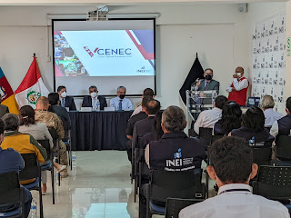
Peru’s 5th National economic Census was launched

Imagen
It plans to cover about 2 million stores nationwide, 100,000 across Piura Department.   Peru’s National Institute of Statistics and Informatics (INEI, as it’s initials in Spanish) launched the 2022 5 th National economic Census (V CENEC, asits initials in Spanish) wwhich was begun on April 18 th across the country purposed to update basic statistical/economic information of companies producing goods and services, that allow to generate economic indicators at geographic, sector, and thematic level.   INEI in Piura Department’s director Martin Herrera Boyer pointed out that the economic census will allow to know the business network nationwide and inside the nation, as well as to identify the economic characteristics of productive units meanwhile knowing much accurate the impact the Covid-19 pandemic comes leaving in the business structure of Peru.   The census might set up economic information to change the basis-year, to estimate the fall of job levels, th...

Don’t look at the sea?

Imagen
A tsunami that put in alert the whole Pacific was not officially warned in Peru – it caused a chain of disasters.   By Nelson Peñaherrera Castillo     FONOAFO’OU, Tonga – On Saturday, January 15 th , 2020, 17:27 Tonga Kingdom Time (0527 GMT), the Hunga Tonga -Hunga Ha’apai Volcano erupted twice in the 1-day lapse causing its structure to collapse into the sea, affecting immediately that South Pacific islander nation.   The column of wáter steam, ashes, and gases got to rise up to 15 miles toward the atmosphere. It was so massive that the Japanese satellite Himawari-8 could capture the cloud caused by the blast as well as the shock waves it generated, even.   According to KNTV station, operating in san Francisco Bay Area, California, the blast power was such as it altered the atmospheric pressure values across the Pacific Ocean – wee are talking about 5318 miles length between that Polinesia sector and that U.S. West Coast portion. ...