Heaven what we see
Learn everything you need to know for saying if you’ll feel hot.
By Axel Córdova, Manuel Espinoza, John Flores, Luis Olivares, Stepany Sánchez and Juan Sernaqué . hotos by the authors.
PIURA CITY, Peru – Unlike another countries, there’s no much culture of checking out the weather forecast. However, it uses to be criticized, especially if it doesn’t match with current conditions. Nevertheless, much people than we imagine are expectant about this information. In Peru, there is an official agency in charge of monitoring , SENAMHI, and there are personalities at the market such as Abraham Levy, or even AccuWeather (used by FACTORTIERRA.NET) to know how dressing, when seeding, or if it’s worthy to have a BBQ.
All data come from meteorological stations installed nationwide, including what National University of Piura (UNP as in Spanish) monitors in Miraflores, Castilla [pronounce “Castija”] District, watching what happens in atmosphere and soil 30 km around. It also receives reports across the region everyday, holidays inclusive. Miraflores Meteorological Station has two areas: Agrimeteorologics, that measures soil temperature, and Climatology, that takes values from air temperature and humidity, those are mostly used for weather forecasts.
The first area is composed by geothermometers buried in different depths. “We’re involved on looking for values of soil behavior,” specialist Milagros Córdova explains. In fact, instruments are set 2 cm, 5 cm, 10 cm, 20 cm, 30 cm, 50 cm and 1 meter, so different values are gotten. “When there’s most solar warming, temperature values are going down, but in some cases, at 2 pm., values raise,” specialist adds.
However, depth is not enough but soil coverage. That’s why the station has three spaces: one where it’s uncovered, another one is grass-covered, and the last one is trash-covered. Then, data are also different. “Uniting the three values and applying formulas, one value is gotten,” Córdova concludes.
Climatology Area has a meteorological box or shelter protected by a windbreaker to avoid data alteration.
It has an aspiretrichrometer, that gives us temperature from dry thermometer and wet thermometer. The two are equal but the wet one has a tiny cloth when getting moisture then becoming colder, allows to know the current temperature. Air relative humidity is calculated from oscillation of both instruments and it’s checked out by a symetrical table.
It also has a thermometer for high temperatures and another for low temperatures. This is the information usually sent to SENAMHI and the media.
But recently, the media are looking for more meteorological parameters, like relative humidity for what the station has a hydrometer, that gives data every 60 minutes. So, combining temperature plus humidity, it’s possible to get thermic sensation, or how cold or heat are perceived by human beings.
Another parameters looked for the media are air direction and intensity, what can be forecasted by using water, water temperature actually. The station has an evaporation tank, which has a gholed hlass and a mycrometric rule for knowing the water level, that is changed every 15 days.
Anemometers allow to have more accurate data of wind, low altitude and at the top of station’s tower as well, where is climbed every 2 weeks to verify its function. Meanwhile, pluviometers say how much rain fell and how much it lasted as well.
A heliometer eases to calculate the hours of solar bright. It’s about a crystal sphere not for predicting the future but how the Sun is interacting to clouds, when estimulating a tissue inside the ball. Additionally, medium clodness is studied, especially cirrus clouds, those are snow drops suspended 9000 meters above our heads, visible from the soil like threads. Their behavior reveals how the wind is moving on.
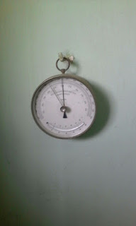
Finally, atmospheric pressure is verified by a barometer , that gives its data in milibars, and a mycrobarometer, That give hem on mercury columns per milbars. And if you know how the wind flows on, how much humidity is, and if it’s cold or hot, you’ll know where and when it will rain. “Any information can be missed,” Córdova emphasizes.
Adapted from the report on Climate Change and Global Warming subject at National University of Piura’s High Technological School.


Comentarios
Publicar un comentario